Difference between revisions of "310 260 1081568"
Jump to navigation
Jump to search
(→Photos: Correct) Tags: Mobile edit Mobile web edit |
(add FCC registration) |
||
| Line 2: | Line 2: | ||
== Photos == | == Photos == | ||
Google Maps: [https://www.google.com/maps/@39.0062741,-104.8185513,3a,15y,159.82h,118.43t/data=!3m6!1e1!3m4!1sqTqzeAZDIkrGAeVtMnEmvQ!2e0!7i13312!8i6656?hl=en&entry=ttu May 2018], close range | Google Maps: [https://www.google.com/maps/@39.0062741,-104.8185513,3a,15y,159.82h,118.43t/data=!3m6!1e1!3m4!1sqTqzeAZDIkrGAeVtMnEmvQ!2e0!7i13312!8i6656?hl=en&entry=ttu May 2018], close range | ||
| Line 29: | Line 27: | ||
On/around December 2022, T-Mobile converted a Sprint site to T-Mobile 5G. | On/around December 2022, T-Mobile converted a Sprint site to T-Mobile 5G. | ||
== | == Regulatory == | ||
* Search for [https://www.pprbd.org/Search/Permit?hasRange=False&RangeDisabled=False&ShowSuite=False&WrapSuiteAndCity=False&lowstnum=455&histnum=455&stname=MIDDLE%20CREEK&sttype=PKWY&stzip=80921&stcity=COLORADO%20SPRINGS&AutoSearch=True&WhichSearch=Basic#SearchJump 455 MIDDLE CREEK PKWY, COLORADO SPRINGS, CO, 80921] | * Search for [https://www.pprbd.org/Search/Permit?hasRange=False&RangeDisabled=False&ShowSuite=False&WrapSuiteAndCity=False&lowstnum=455&histnum=455&stname=MIDDLE%20CREEK&sttype=PKWY&stzip=80921&stcity=COLORADO%20SPRINGS&AutoSearch=True&WhichSearch=Basic#SearchJump 455 MIDDLE CREEK PKWY, COLORADO SPRINGS, CO, 80921] | ||
* permit issued issued 10/12/2023 [https://www.pprbd.org/Permit/Details?permitNo=O93277 O93277] | * permit issued issued 10/12/2023 [https://www.pprbd.org/Permit/Details?permitNo=O93277 O93277] | ||
* 11024 HWY 83: previous address | * 11024 HWY 83: previous address | ||
* FCC ARS registration [https://wireless2.fcc.gov/UlsApp/AsrSearch/asrRegistration.jsp?regKey=615664 1054803] constructed 1998, listed at 11020 HIGHWAY 23 | |||
== Speed test == | == Speed test == | ||
Revision as of 16:36, 10 February 2024
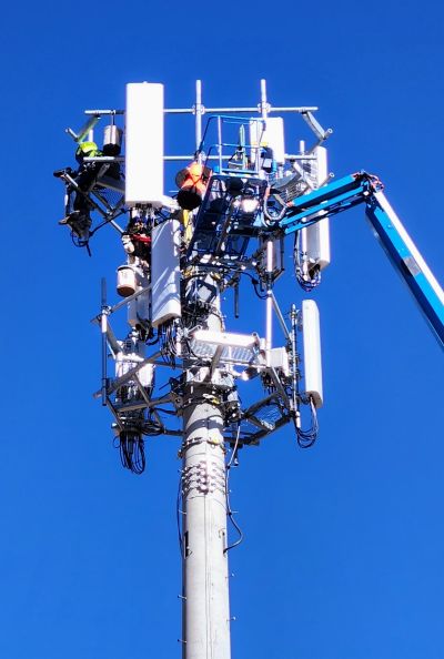
This is a macro tower at 555 Middle Creek Pkwy (Google Map).
Photos
Google Maps: May 2018, close range
For photo (January 2023) and discussion, see Reddit post.
Photo on 2023-10-26 from south during upgrade to add N71:
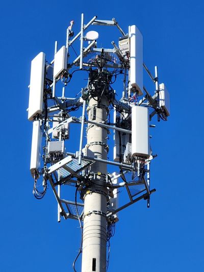
Photo taken on 2023-11-02 from north. The circle may be pointing maybe NE towards 12290 Voyager which is owned by Compassion, like 555 Middle Creek.
Carriers
- T-Mobile (top rack) since December 2022
- gNB ID 1081568 (Macro) - NR [this page]
- eNB ID 384725 (Macro) - LTE
- eNB ID 384726 (Macro) - LTE
- Sprint until December 2022
- eNB ID 540918 (Macro) - LTE [MCC/NC: 312 / 250 and 310 / 120 ]
- Dish (bottom rack)
On/around December 2022, T-Mobile converted a Sprint site to T-Mobile 5G.
Regulatory
- Search for 455 MIDDLE CREEK PKWY, COLORADO SPRINGS, CO, 80921
- permit issued issued 10/12/2023 O93277
- 11024 HWY 83: previous address
- FCC ARS registration 1054803 constructed 1998, listed at 11020 HIGHWAY 23
Speed test
Galaxy S22 from the parking Lot, February 2023
- NR NSA: B66+N41+N41 + B2 for 15+100+40+15 MHz, -68 dBm: 615.22/103.39 Mbps, 69 ms (test results)
- NR SA: N41+N25+N41 for 100+15+40MHz, -73 dBm: 514.01/73.29 Mbps, 62 ms (test results)
March 10, 2023
Close range, indoors
Galaxy S22, Google Fi (i.e., not TMHI), N41+n41 (140MHz), -75 RSRP, 22.2 SINR
- 8:28am, 463.63/5.00 Mbps, 71 ms: https://www.speedtest.net/result/a/9122013581
Arcadyan KVD21 gateway (TMHI) via wifi to Galaxy S22
- 8:29am, 538.35/96.44 Mbps, 18 ms: https://www.speedtest.net/result/a/9122016037
- 8:30am, 551.86/93.68 Mbps, 20 ms: https://www.speedtest.net/result/a/9122018654
Signal stats for the gateway
"signal": {
    "4g": {
      "bands": [
        "b2"
      ],
      "bars": 5.0,
      "cid": 11,
      "eNBID": 384725,
      "rsrp": -68,
      "rsrq": -9,
      "rssi": -59,
      "sinr": 18
    },
    "5g": {
      "bands": [
        "n41"
      ],
      "bars": 5.0,
      "cid": 0,
      "gNBID": 0,
      "rsrp": -63,
      "rsrq": 2,
      "rssi": -66,
      "sinr": 30
    }
Nearby
- Verizon 350ft away on the roof of closest building
- T-Mobile 102691 0.5 mile away to east on other building, also owned by Compassion

