Difference between revisions of "310 260 1073551"
(create) |
(→Permits, registration: add FAA study) |
||
| (3 intermediate revisions by the same user not shown) | |||
| Line 1: | Line 1: | ||
T-Mobile | T-Mobile hidden in a building on a hiking trail near Blodgett Open Space Parking | ||
This site covers a wide area between North Gate Blvd (north), north of Austin Bluffs Pkwy (south), and Powers (east). The antennas as pointed only east, so when hiking to the west, coverage is provided by many towers to the east such as the one at Union and Research. | |||
Its housed in a unique building purpose built for one cell site. The back (facing the mountain) looks janky because only hikers see it, while the side facing to the east is open to allow signals through. | |||
On reddit, [https://www.reddit.com/r/cellmapper/comments/13vai7w/carrier_identification_please_7_photos/ thisisausername190 identified] two photos as "T-Mobile Nokia AEHC" and "Dish JMA MX08FRO665-21 / Fujitsu RAN." | |||
== Photos == | |||
Photos taken April 7, 2023. | |||
<gallery> | |||
File:2023-04-07 TMobile gNB 1073551 1.jpg | |||
File:2023-04-07 TMobile gNB 1073551 2.jpg|Dish JMA MX08FRO665-21 / Fujitsu RAN | |||
File:2023-04-07 TMobile gNB 1073551 3.jpg|T-Mobile Nokia AEHC | |||
File:2023-04-07 TMobile gNB 1073551 4.jpg | |||
</gallery> | |||
== Speed test == | |||
* April 2023 | |||
* Google Fi | |||
* Taken at 38.9424096,-104.880743 (300 feet away) on the west side. (The antennas point to the east.) | |||
* 613 Mbps down | |||
* https://www.speedtest.net/my-result/a/9189175682 | |||
== Regulatory == | |||
FCC ARS [https://wireless2.fcc.gov/UlsApp/AsrSearch/asrRegistration.jsp?regKey=2648869 Registration 1249705] | |||
* 4098 W. Woodmen Rd | |||
* Constructed 08/21/2006 | |||
* silo | |||
FAA study [https://oeaaa.faa.gov/oeaaa/external/searchAction.jsp?action=displayOECase&oeCaseID=444626&row=0 2005-ANM-2609-OE] for Sprint Nextel at 4098 W Woodman Rd | |||
[[Category:T-Mobile in El Paso County Colorado]] | |||
[[Category:speed test]] | |||
Latest revision as of 17:10, 10 February 2024
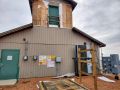
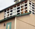
T-Mobile hidden in a building on a hiking trail near Blodgett Open Space Parking
This site covers a wide area between North Gate Blvd (north), north of Austin Bluffs Pkwy (south), and Powers (east). The antennas as pointed only east, so when hiking to the west, coverage is provided by many towers to the east such as the one at Union and Research.
Its housed in a unique building purpose built for one cell site. The back (facing the mountain) looks janky because only hikers see it, while the side facing to the east is open to allow signals through.
On reddit, thisisausername190 identified two photos as "T-Mobile Nokia AEHC" and "Dish JMA MX08FRO665-21 / Fujitsu RAN."
Photos
Photos taken April 7, 2023.
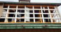
Dish JMA MX08FRO665-21 / Fujitsu RAN
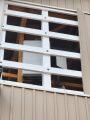
T-Mobile Nokia AEHC


Speed test
- April 2023
- Google Fi
- Taken at 38.9424096,-104.880743 (300 feet away) on the west side. (The antennas point to the east.)
- 613 Mbps down
- https://www.speedtest.net/my-result/a/9189175682
Regulatory
FCC ARS Registration 1249705
- 4098 W. Woodmen Rd
- Constructed 08/21/2006
- silo
FAA study 2005-ANM-2609-OE for Sprint Nextel at 4098 W Woodman Rd