Difference between revisions of "310 260 95521"
Jump to navigation
Jump to search
m |
|||
| (20 intermediate revisions by the same user not shown) | |||
| Line 1: | Line 1: | ||
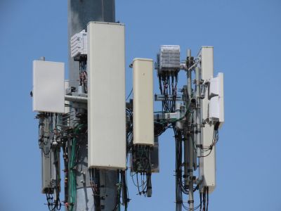
https:// | '''T-Mobile antennas:''' <small>(shot on: 5/1/22)</small> <br> | ||
[[File:Raccooncast_IMG_2738.JPG|400px]] <br> | |||
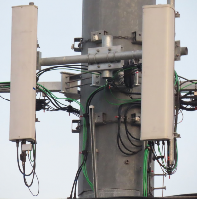
'''Previous T-Mobile antennas:''' <small>(shot on: 11/20/20)</small> <br> | |||
[[File:AMdLsdr.png|400px]] <br> | |||
'''Previous² T-Mobile''' [https://goo.gl/maps/BmnwCnvNKtHyTgY7A Street View] <br> | |||
'''Previous³ MetroPCS''' [https://goo.gl/maps/t6fxEhYmYWwEDY8Q6 Street View] <br> | |||
'''Antennas:''' <small>(left-to-right)</small> <br> | |||
# Ericsson AIR 6449 B41 | |||
# [https://www.rfstechnologies.com/pim/product/html/APXVAALL24_43-U-NA20 RFS APXVAALL24_43-U-NA20] | |||
# Ericsson AIR 32 | |||
'''Pre-upgrade: ''' <small>(left-to-right)</small> <br> | |||
# Possibly Andrew SHBX-6516DS-VTM | |||
# Ericsson AIR 32 | |||
'''See also:''' <br> | |||
1 [https://docs.cellmapper.net/mw/File:Raccooncast_IMG_2742.JPG Full tower shot, shot taken before Verizon C-band was added] <br> | |||
2. [https://planning.lacity.org/pdiscaseinfo/caseid/MTU0NDcz0 T-Mobile/MetroPCS City planning records] <br> | |||
3. [https://www.ladbsservices2.lacity.org/OnlineServices/PermitReport/PermitResults/775445 LADBS Permits] <br> | |||
4. [https://docs.cellmapper.net/mw/File:20210521153813_IMG_0593_(1).JPG Alt photo] | |||
Latest revision as of 17:32, 3 October 2023
T-Mobile antennas: (shot on: 5/1/22)

Previous T-Mobile antennas: (shot on: 11/20/20)

Previous² T-Mobile Street View
Previous³ MetroPCS Street View
Antennas: (left-to-right)
- Ericsson AIR 6449 B41
- RFS APXVAALL24_43-U-NA20
- Ericsson AIR 32
Pre-upgrade: (left-to-right)
- Possibly Andrew SHBX-6516DS-VTM
- Ericsson AIR 32
See also:
1 Full tower shot, shot taken before Verizon C-band was added
2. T-Mobile/MetroPCS City planning records
3. LADBS Permits
4. Alt photo