Difference between revisions of "310 120 780054"
Jump to navigation
Jump to search
(Created page with "225px|thumb|left|Looking WSW Clark County (Spirit Mountain), NV: 35.251354, -114.746931<br />") |
|||
| (3 intermediate revisions by the same user not shown) | |||
| Line 1: | Line 1: | ||
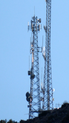
[[File:310_120_780054.jpg|225px|thumb|left| | [[File:310_120_780054.jpg|225px|thumb|left|On a high point of Spirit Mountain south of Christmas Tree Pass. (8/2021)]]<br /> | ||
Sprint LTE B25,26/CDMA BC10<br /> | |||
Tower mount: 1 (3 sectors)<br /> | |||
Equipment: undetermined sector antennas, ground RRH | |||
Location: 35.251354, -114.746931<br /> | |||
(8 mi. ESE of) Cal-Nev-Ari, NV<br /> | |||
Structure: Self-supporting lattice tower<br /> | |||
Height: 115 ft.<br /> | |||
Elevation: 4903 ft<br /> | |||
Built: 7/1998 | |||
Latest revision as of 04:32, 26 September 2022
Sprint LTE B25,26/CDMA BC10
Tower mount: 1 (3 sectors)
Equipment: undetermined sector antennas, ground RRH
Location: 35.251354, -114.746931
(8 mi. ESE of) Cal-Nev-Ari, NV
Structure: Self-supporting lattice tower
Height: 115 ft.
Elevation: 4903 ft
Built: 7/1998
