Difference between revisions of "North 32nd Street, Colorado Springs"
Jump to navigation
Jump to search
(create from other page) |
(add new permit) |
||
| (One intermediate revision by the same user not shown) | |||
| Line 3: | Line 3: | ||
[[File:2024-01-21 N 32nd St roof.jpg|400px|taken 2024-01-21]] | [[File:2024-01-21 N 32nd St roof.jpg|400px|taken 2024-01-21]] | ||
The site is | The site is on [https://www.google.com/maps/@38.8581896,-104.8727727,3a,15y,133.99h,101.64t/data=!3m6!1e1!3m4!1s-JXkNQdgw0QFaozqL4X58g!2e0!7i16384!8i8192?entry=ttu Google Street View] and [https://www.google.com/maps/place/38%C2%B051'28.1%22N+104%C2%B052'20.1%22W/@38.8577762,-104.872316,77m/data=!3m1!1e3!4m4!3m3!8m2!3d38.8578144!4d-104.872243?entry=ttu satellite view] | ||
Verizon 16896 was pinned slightly wrong at 3202 W Platte Ave by Cjaiceman | Verizon 16896 was pinned slightly wrong at 3202 W Platte Ave by Cjaiceman | ||
| Line 11: | Line 11: | ||
PPRBD [https://www.pprbd.org/Search/Plan?suite=A&hasRange=False&RangeDisabled=False&ReadOnly=False&ShowSuite=False&WrapSuiteAndCity=False&ShowZip=False&ShowParcel=False&UseBootstrapDangerStyle=False&lowstnum=121&histnum=121&stdir=N&stname=32ND&sttype=ST&stzip=80904&stcity=COLORADO%20SPRINGS&modid=0&tid=0plan search] and [https://www.pprbd.org/Search/Permit?suite=A&hasRange=False&RangeDisabled=False&ReadOnly=False&ShowSuite=False&WrapSuiteAndCity=False&ShowZip=False&ShowParcel=False&UseBootstrapDangerStyle=False&lowstnum=121&histnum=121&stdir=N&stname=32ND&sttype=ST&stzip=80904&stcity=COLORADO%20SPRINGS&modid=0&tid=0 permit search] | PPRBD [https://www.pprbd.org/Search/Plan?suite=A&hasRange=False&RangeDisabled=False&ReadOnly=False&ShowSuite=False&WrapSuiteAndCity=False&ShowZip=False&ShowParcel=False&UseBootstrapDangerStyle=False&lowstnum=121&histnum=121&stdir=N&stname=32ND&sttype=ST&stzip=80904&stcity=COLORADO%20SPRINGS&modid=0&tid=0plan search] and [https://www.pprbd.org/Search/Permit?suite=A&hasRange=False&RangeDisabled=False&ReadOnly=False&ShowSuite=False&WrapSuiteAndCity=False&ShowZip=False&ShowParcel=False&UseBootstrapDangerStyle=False&lowstnum=121&histnum=121&stdir=N&stname=32ND&sttype=ST&stzip=80904&stcity=COLORADO%20SPRINGS&modid=0&tid=0 permit search] | ||
* [https://www.pprbd.org/Permit/Details?permitNo=P23828]: CELL SITE MODIFICATION- T-MOBILE 4/9/2024, likely upgrade from LTE to NR | |||
* [https://www.pprbd.org/Plan/Details?Id=C179868&SpliceNum=&tid=170412 C179868]: CELL SITE MODIFICATION- T-MOBILE at 121 N. 32ND ST, | * [https://www.pprbd.org/Plan/Details?Id=C179868&SpliceNum=&tid=170412 C179868]: CELL SITE MODIFICATION- T-MOBILE at 121 N. 32ND ST, | ||
* [https://www.pprbd.org/Plan/Details?Id=C166479&SpliceNum=&tid=157195 C166479]: The address for this Verizon installation is 115 1/2 N. | * [https://www.pprbd.org/Plan/Details?Id=C166479&SpliceNum=&tid=157195 C166479]: "The address for this Verizon installation is 115 1/2 N." | ||
* [https://www.pprbd.org/Permit/Details?permitNo=D50282 D50282] roof mount antenna 1999 | * [https://www.pprbd.org/Permit/Details?permitNo=D50282 D50282] roof mount antenna 1999 | ||
Latest revision as of 14:32, 10 April 2024
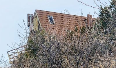
This is T-Mobile and Verizon on the roof on North 32nd Street at addresses 115, and 121, 121 1/2
The site is on Google Street View and satellite view
Verizon 16896 was pinned slightly wrong at 3202 W Platte Ave by Cjaiceman
Regulatory
PPRBD search and permit search
- [1]: CELL SITE MODIFICATION- T-MOBILE 4/9/2024, likely upgrade from LTE to NR
- C179868: CELL SITE MODIFICATION- T-MOBILE at 121 N. 32ND ST,
- C166479: "The address for this Verizon installation is 115 1/2 N."
- D50282 roof mount antenna 1999
Call sign WQAB859 for Sprint Nextel (later T-Mobile)
