Difference between revisions of "208 1 61984"
Jump to navigation
Jump to search
(Updated content at the top of the page.) |
(Updated content before balise.) |
||
| Line 7: | Line 7: | ||
'''[https://data.anfr.fr/anfr/visualisation/table/?id=dd11fac6-4531-4a27-9c8c-a3a9e4ec2107&refine.sup_id=2319539 ANFR]''' | '''[https://data.anfr.fr/anfr/visualisation/table/?id=dd11fac6-4531-4a27-9c8c-a3a9e4ec2107&refine.sup_id=2319539 ANFR]''' | ||
'''[https://enb-analytics.fr/ | '''[https://enb-analytics.fr/page_recherche_analyse.html?type=enb&plmn=20801&val=61984 EAnalytics]''' | ||
'''[https://www.google.com/maps/search/?api=1&query=47.650277777778%2C-3.114444444444 MAPS]''' | '''[https://www.google.com/maps/search/?api=1&query=47.650277777778%2C-3.114444444444 MAPS]''' | ||
'''[https:// | Distance comparaison ANFR: 16m | ||
'''{{:ANFR ID 2319539}}''' | |||
[https://www.cellmapper.net/map?MCC=208&MNC=1&type=LTE&latitude=47.65040720167801&longitude=-3.114553419374459&zoom=15&showTowers=true&showIcons=false&showTowerLabels=true&clusterEnabled=false&tilesEnabled=false&showOrphans=true&showNoFrequencyOnly=false&showFrequencyOnly=false&showBandwidthOnly=false&DateFilterType=None&showHex=false&showVerifiedOnly=false&showUnverifiedOnly=false&showLTECAOnly=false&showENDCOnly=false&showBand=0&showSectorColours=true&mapType=roadmap&darkMode=false&imperialUnits=false Cette antenne] | |||
<!-- DO NOT EDIT ABOVE --> | |||
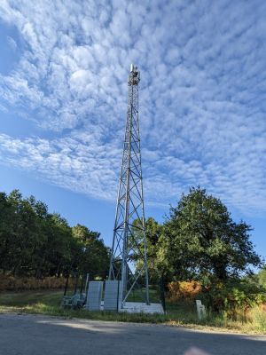
[[File:PXL_20220723_071707741_small.jpg|thumb|Orange 4G+ Antennas next to the road, Keriscouarne, 56400 Ploemel, France]] | [[File:PXL_20220723_071707741_small.jpg|thumb|Orange 4G+ Antennas next to the road, Keriscouarne, 56400 Ploemel, France]] | ||
Revision as of 08:37, 9 August 2023
Support ANFR n°2319539 ( H:36m)
Opérateurs sur ce support (ANFR):🟠
Distance comparaison ANFR: 16m
| Support ANFR n°2319539 🗺️/📷 | |
|---|---|
| Nature | Pylône autostable |
| Hauteur TOT | 36.0m |
| Propriétaire | ATC FRANCE |
| Exploitants | ORANGE, ORANGE service fixe |
| Nb antennes | 4 |
| Antenne ORANGE service fixe | |
|---|---|
| Hauteur | 30.0m |
| Type | Antenne parabolique |
| Orientation (1) | 288.8° |
| Emetteur(s) | |
| FH (CARTE) | |
| - ORANGE service fixe: ✅ 20/08/2021 ↳ 0.1 GHz (22.4 GHz-22.5 GHz) ↳ 0.1 GHz (22.4 GHz-22.5 GHz) | |
| Antenne ORANGE | |
|---|---|
| Hauteur | 34.7m |
| Type | Panneau |
| Orientations (2) | 40.0°, 300.0° |
| Emetteur(s) | |
| 4G - LTE 1800 | |
| - 🟧 ORANGE: ✅ 17/09/2021 ↳ 20.0 MHz (1710.0 MHz-1730.0 MHz) ↳ 20.0 MHz (1805.0 MHz-1825.0 MHz) | |
| 4G - LTE 2100 | |
| - 🟧 ORANGE: ✅ 23/09/2021 ↳ 14.8 MHz (1964.9 MHz-1979.7 MHz) ↳ 14.8 MHz (2154.9 MHz-2169.7 MHz) | |
| 4G - LTE 2600 | |
| - 🟧 ORANGE: ✅ 20/09/2021 ↳ 20.0 MHz (2515.0 MHz-2535.0 MHz) ↳ 20.0 MHz (2635.0 MHz-2655.0 MHz) | |
| 4G - LTE 700 | |
| - 🟧 ORANGE: ✅ 22/09/2021 ↳ 10.0 MHz (708.0 MHz-718.0 MHz) ↳ 10.0 MHz (763.0 MHz-773.0 MHz) | |
| 4G - LTE 800 | |
| - 🟧 ORANGE: ✅ 22/09/2021 ↳ 10.0 MHz (811.0 MHz-821.0 MHz) ↳ 10.0 MHz (852.0 MHz-862.0 MHz) | |
| 3G - UMTS 900 | |
| - 🟧 ORANGE: ✅ 22/09/2021 ↳ 8.7 MHz (889.9 MHz-898.6 MHz) ↳ 8.7 MHz (934.9 MHz-943.6 MHz) | |
| Antenne ORANGE | |
|---|---|
| Hauteur | 34.7m |
| Type | Panneau |
| Orientation (1) | 150.0° |
| Emetteur(s) | |
| 4G - LTE 1800 | |
| - 🟧 ORANGE: ✅ 17/09/2021 ↳ 20.0 MHz (1710.0 MHz-1730.0 MHz) ↳ 20.0 MHz (1805.0 MHz-1825.0 MHz) | |
| 4G - LTE 2600 | |
| - 🟧 ORANGE: ✅ 20/09/2021 ↳ 20.0 MHz (2515.0 MHz-2535.0 MHz) ↳ 20.0 MHz (2635.0 MHz-2655.0 MHz) | |
| 4G - LTE 700 | |
| - 🟧 ORANGE: ✅ 22/09/2021 ↳ 10.0 MHz (708.0 MHz-718.0 MHz) ↳ 10.0 MHz (763.0 MHz-773.0 MHz) | |
| 4G - LTE 800 | |
| - 🟧 ORANGE: ✅ 22/09/2021 ↳ 10.0 MHz (811.0 MHz-821.0 MHz) ↳ 10.0 MHz (852.0 MHz-862.0 MHz) | |
| 3G - UMTS 900 | |
| - 🟧 ORANGE: ✅ 22/09/2021 ↳ 8.7 MHz (889.9 MHz-898.6 MHz) ↳ 8.7 MHz (934.9 MHz-943.6 MHz) | |
| Station N°0560220110 | |
|---|---|
| Exploitant | ORANGE service fixe |
| Implantation | 07/08/2020 |
| Mise en service | 20/08/2021 |
| Modification | |
| Station N°0562290393 | |
| Exploitant | ORANGE |
| Implantation | 21/08/2020 |
| Mise en service | 17/09/2021 |
| Modification | 13/05/2022 |
Antennas next to the road, Keriscouarne, 56400 Ploemel, France. At the corner of the golf curs.
Antenne ID 2319539 Orange Speed 4G+
47.650410, -3.114553
