Difference between revisions of "Garry Berry Stadium, Colorado Springs"
Jump to navigation
Jump to search
(create) |
(add text; reorganize; re-think T-Mobile location) |
||
| Line 1: | Line 1: | ||
Garry Berry Stadium is at 38.860860429888746, -104.78007241168127, which is next to Roy J. Wasson high school. The stadium is by Patrician Way, Glenn Summer Road, and Constitution Ave. | Garry Berry Stadium is at 38.860860429888746, -104.78007241168127, which is next to Roy J. Wasson high school. The stadium is by Patrician Way, Glenn Summer Road, and Constitution Ave. | ||
At this site, T-Mobile has GSM and LTE, and it formerly had UMTS. It is unusual that it has three LTE eNBs (22069,38809,31006), but it doesn't have B41, B71, or NR. | |||
== | == Southeast pole == | ||
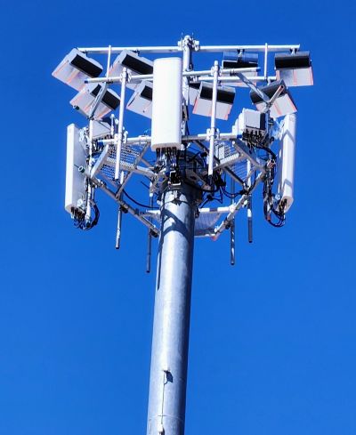
The southeast tower looks like Dish. | |||
[[File: | [[File:20230401_114132 Wasson High School.jpg|400px|southeast part of stadium, taken 4/1/2023]] | ||
Google Street View [https://www.google.com/maps/@38.8602468,-104.7794644,3a,16.4y,350.4h,134.49t/data=!3m10!1e1!3m8!1szIDyuYdz76UN20c09MvYcA!2e0!6shttps:%2F%2Fstreetviewpixels-pa.googleapis.com%2Fv1%2Fthumbnail%3Fpanoid%3DzIDyuYdz76UN20c09MvYcA%26cb_client%3Dmaps_sv.tactile.gps%26w%3D203%26h%3D100%26yaw%3D139.37875%26pitch%3D0%26thumbfov%3D100!7i16384!8i8192!9m2!1b1!2i28 photo (October 2019)] shows a previous tenant. | |||
== Northeast pole == | |||
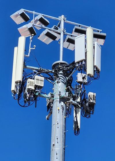
[[File:20230401_114232 Wasson High School.jpg|400px|northeast part of stadium, taken 4/1/2023]] | |||
Google Street View [https://www.google.com/maps/@38.8604259,-104.7793931,3a,15y,11.32h,111.53t/data=!3m6!1e1!3m4!1stjNaXIRFVmz2e4NHeCLd9A!2e0!7i16384!8i8192 photo (October 2019)]. | |||
== Northwest pole == | |||
Google Street View photo [https://www.google.com/maps/@38.8618634,-104.7798005,3a,15y,215.41h,93.78t/data=!3m7!1e1!3m5!1s0Yi5ZtI9WDvX9agg8xLcMQ!2e0!6shttps:%2F%2Fstreetviewpixels-pa.googleapis.com%2Fv1%2Fthumbnail%3Fpanoid%3D0Yi5ZtI9WDvX9agg8xLcMQ%26cb_client%3Dmaps_sv.tactile.gps%26w%3D203%26h%3D100%26yaw%3D303.00934%26pitch%3D0%26thumbfov%3D100!7i16384!8i8192 northeast side] shows a wider pole but no visible antennas. | |||
== Permits/Registration == | == Permits/Registration == | ||
Revision as of 03:36, 2 April 2023
Garry Berry Stadium is at 38.860860429888746, -104.78007241168127, which is next to Roy J. Wasson high school. The stadium is by Patrician Way, Glenn Summer Road, and Constitution Ave.
At this site, T-Mobile has GSM and LTE, and it formerly had UMTS. It is unusual that it has three LTE eNBs (22069,38809,31006), but it doesn't have B41, B71, or NR.
Southeast pole
The southeast tower looks like Dish.
Google Street View photo (October 2019) shows a previous tenant.
Northeast pole
Google Street View photo (October 2019).
Northwest pole
Google Street View photo northeast side shows a wider pole but no visible antennas.
Permits/Registration
No related permits found at PPRBD on Afton Way, Patrician Way, Glenn Summer Rd, or 2000-3000 Constituent Ave from 2001-2023

