Difference between revisions of "Pebble Beach Way, Monument, CO"
Jump to navigation
Jump to search
(→Permit: add FCC) |
(→Permits and registration: add FCC) |
||
| Line 18: | Line 18: | ||
* [https://www.antennasearch.com/HTML/individual/antenna.php?unique_system_identifier=3761810&call_sign=WQWW544&location_number=1 FCC WQWW544] | * [https://www.antennasearch.com/HTML/individual/antenna.php?unique_system_identifier=3761810&call_sign=WQWW544&location_number=1 FCC WQWW544] | ||
* [https://www.antennasearch.com/HTML/individual/antenna.php?unique_system_identifier=3543079&call_sign=WQSY704&location_number=1 FCC WQSY704] | * [https://www.antennasearch.com/HTML/individual/antenna.php?unique_system_identifier=3543079&call_sign=WQSY704&location_number=1 FCC WQSY704] | ||
* [https://www.antennasearch.com/HTML/individual/antenna.php?unique_system_identifier=3761812&call_sign=WQWW546&location_number=2 FCC WQWW546] | |||
== Historical location == | == Historical location == | ||
Latest revision as of 06:58, 10 February 2024
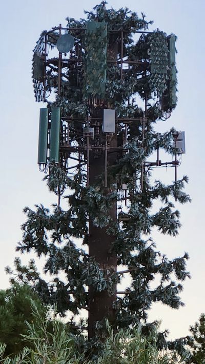
Verizon and T-Mobile are co-located on a stealth tree at the Country Club at Woodmoor.
Photos
Google Street View is not available nearby as of September 2023.
Speed test
Speed test 2023-09-04 on Samsung Galaxy S22+ using Google Fi (T-Mobile), NR NSA: 675.26 Mbps/135.48 Mbps, 19 ms (results)
Permits and registration
- L42385: 18975 PEBBLE BEACH WAY, MONUMENT, CO, 80132; Verizon; October 2018 to January 2019
- O28399: 18945 PEBBLE BEACH WAY, MONUMENT, CO, 80132; T-Mobile; August to October 2022
- G34007: 18945 PEBBLE BEACH WAY; cellular monopine / T-Mobile; 2007
- FCC WQWW544
- FCC WQSY704
- FCC WQWW546
Historical location
This site was hard to locate because of the terrain and its unpopular location.
- Verizon LTE eNB 16770: as of 2023-09-05, the red dot was at 39.0235953,-104.8692248 for an error of 5.9 miles after four years since it was first seen on CellMapper.
- Verizon LTE eNB 316770 as of 2023-09-05, the red dot was at 39.0951049,-104.8341637 (Winding Meadow Way)
- T-Mobile GSM NB 3601: as of 2023-09-05, the red dot was at 39.08440938073491,-104.8462803422115 (937 Caribou Dr W, Monument, CO 80132) for an error of 1.5 miles after four years since it was first seen on CellMapper.
- T-Mobile LTE eNB 27992 as of 2023-08-20: the red dot was south of Fairplay between Hibgy and Lost Pines Drive for an error of 2.3 miles after almost eight years since it was first seen on CellMapper.
- T-Mobile NR gNB 1049558 as of 2023-09-05: the red dot was at 39.0651123,-104.8526085 (between Walmart and Home Depot) for an error of 2.9 miles after almost one year since it was first seen on CellMapper.
