Difference between revisions of "208 1 58857"
Jump to navigation
Jump to search
Valenfrance (talk | contribs) |
(Updated content at the top of the page.) |
||
| Line 1: | Line 1: | ||
'''[https://www.cartoradio.fr/index.html#/cartographie/lonlat/-3.071111111111/47.651111111111 Support ANFR n°509509 ( H:35m)]''' | |||
'''Opérateurs sur ce support (ANFR):'''[https://www.cellmapper.net/map?MCC=208&MNC=1&type=LTE&latitude=47.651063&longitude=-3.071062&zoom=15&showTowers=true&showIcons=false&showTowerLabels=true&clusterEnabled=false&tilesEnabled=false&showOrphans=true&showNoFrequencyOnly=false&showFrequencyOnly=false&showBandwidthOnly=false&DateFilterType=None&showHex=false&showVerifiedOnly=false&showUnverifiedOnly=false&showLTECAOnly=false&showENDCOnly=false&showBand=0&showSectorColours=true&mapType=roadmap&darkMode=false&imperialUnits=false 🟠] | |||
'''[https://www.cartoradio.fr/index.html#/cartographie/lonlat/-3.071111111111/47.651111111111 CARTORADIO]''' | |||
'''[https://data.anfr.fr/anfr/visualisation/table/?id=dd11fac6-4531-4a27-9c8c-a3a9e4ec2107&refine.sup_id=509509 ANFR]''' | |||
'''[https://enb-analytics.fr/page_recherche_support.html?sup_id=509509 EAnalytics]''' | |||
'''[https://www.google.com/maps/search/?api=1&query=47.651111111111%2C-3.071111111111 MAPS]''' | |||
'''[https://carte-fh.lafibre.info/index.php?no_sup_init=509509 CARTE FH]''' | |||
Distance comparaison ANFR: 6m | |||
<><><><><><><><><><><><><><> | |||
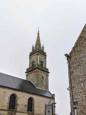
[[File:IMG 20200621 092401.jpg|thumb|Église Saint-André, 56400 Ploemel, France]] | [[File:IMG 20200621 092401.jpg|thumb|Église Saint-André, 56400 Ploemel, France]] | ||
Revision as of 23:23, 16 June 2023
Support ANFR n°509509 ( H:35m)
Opérateurs sur ce support (ANFR):🟠
Distance comparaison ANFR: 6m
<><><><><><><><><><><><><><>
Antennas on the tower of the church, Église Saint-André, 56400 Ploemel, France
47.651063,-3.071062
