Difference between revisions of "310 260 87017"
Jump to navigation
Jump to search
m |
m |
||
| (11 intermediate revisions by the same user not shown) | |||
| Line 1: | Line 1: | ||
[[File: | '''N71 upgrade''' <small>(shot on: 5/7/22)</small>: <br> | ||
[[File:Raccooncast IMG 2901.JPG|400px]] <br> | |||
'''mmW upgrade''' <small>(shot on: 3/3/22)</small>: <br> | |||
[[File:20220303084348 IMG 1797 (1).JPG|400px]] <br> | |||
'''Antennas as of 5/7/22:''' <small>[https://www.permitla.org/ipars/list_appl.cfm?ID1=20016&ID2=10000&ID3=04914&ADDRESS=434%20%20S%20GRAND%20AVE%20%2090071 2020 Permit]</small> (n71)<br> | |||
1. '''Ericsson AIR 32''' <small>(2/66)</small> | |||
2. '''Ericsson AIR 5121''' <small>(n261)</small> | |||
3. '''[https://www.commscope.com/product-type/antennas/base-station-antennas-equipment/base-station-antennas/itemffhh-65a-r3/ FFHH-65A-R3]''' <small>(B12/B71)</small> | |||
4. '''Ericsson AIR 21''' <small>(2G/3G)</small> | |||
'''Antennas as of 3/3/22:''' <small>[https://www.ladbsservices2.lacity.org/OnlineServices/PermitReport/PcisPermitDetail?id1=18016&id2=10000&id3=19132 2019 permit]</small> ([https://planning.lacity.org/pdiscaseinfo/search/encoded/Mzc0NjA0 mmW+LAA], only mmW deployed)<br> | |||
1. '''Ericsson AIR 32''' <small>(2/66)</small> | |||
2. '''Ericsson AIR 5121''' <small>(n261)</small> | |||
3. '''[https://www.commscope.com/product-type/antennas/base-station-antennas-equipment/base-station-antennas/itemlnx-6514ds-a1m/ Commscope LNX-6514DS-A1M]''' <small>(B12)</small> | |||
4. '''Ericsson AIR 21''' <small>(2G/3G)</small> | |||
Sector A: the nearby eNB 87026. <br> | |||
Sector B: the nearby eNB 87026. <br> | |||
Sector C: [https://www.google.com/maps/search/34.0505701244,-118.253401095 34.0505, -118.2534] [https://goo.gl/maps/5sTQisndydmsmQGm9 Street View] | |||
Latest revision as of 02:14, 9 July 2022
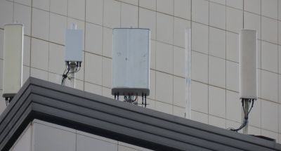
N71 upgrade (shot on: 5/7/22):

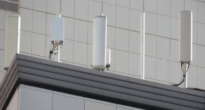
mmW upgrade (shot on: 3/3/22):

Antennas as of 5/7/22: 2020 Permit (n71)
1. Ericsson AIR 32 (2/66)
2. Ericsson AIR 5121 (n261)
3. FFHH-65A-R3 (B12/B71)
4. Ericsson AIR 21 (2G/3G)
Antennas as of 3/3/22: 2019 permit (mmW+LAA, only mmW deployed)
1. Ericsson AIR 32 (2/66)
2. Ericsson AIR 5121 (n261)
3. Commscope LNX-6514DS-A1M (B12)
4. Ericsson AIR 21 (2G/3G)
Sector A: the nearby eNB 87026.
Sector B: the nearby eNB 87026.
Sector C: 34.0505, -118.2534 Street View