Difference between revisions of "310 260 87026"
Jump to navigation
Jump to search
m |
m |
||
| Line 5: | Line 5: | ||
# [https://www.rfsworld.com/pim/product/html/APXVAALL18_43-U-NA20 RFS APXVAALL18_43-U-NA20] <small>(B12,B71)</small> | # [https://www.rfsworld.com/pim/product/html/APXVAALL18_43-U-NA20 RFS APXVAALL18_43-U-NA20] <small>(B12,B71)</small> | ||
# Ericsson AIR 5121 <small>(mmW)</small> | # Ericsson AIR 5121 <small>(mmW)</small> | ||
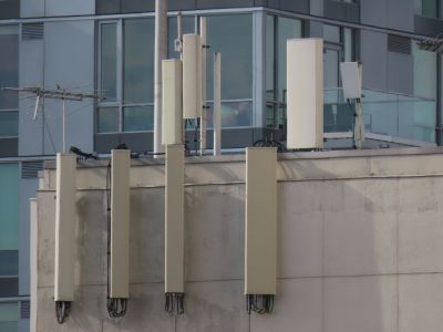
The bottom antennas are AT&T's. | |||
Sector A is at [https://www.google.com/maps/search/34.05030,-118.25240 34.05030,-118.25240] [https://goo.gl/maps/BMFfMd3wi72hKa6T9 Street View] <br> | Sector A is at [https://www.google.com/maps/search/34.05030,-118.25240 34.05030,-118.25240] [https://goo.gl/maps/BMFfMd3wi72hKa6T9 Street View] <br> | ||
Revision as of 21:34, 28 April 2022
- Ericsson AIR 21
- Ericsson AIR 32
- RFS APXVAALL18_43-U-NA20 (B12,B71)
- Ericsson AIR 5121 (mmW)
The bottom antennas are AT&T's.
Sector A is at 34.05030,-118.25240 Street View
Sector B is at 34.05003,-118.25255 Street View
Sector C is at the nearby eNB 87017.
pdf: LADBS Permit Plans
