Difference between revisions of "311 480 59415"
Jump to navigation
Jump to search
(Add locations) |
(Add photos) |
||
| Line 1: | Line 1: | ||
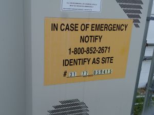
This eNB is used for two cell sites. Verizon treats them as a small cell group (specifically, <code>WESTBORO_OTIS_ST_MA_SC01</code> and <code>SC02</code>), but they are both rooftop installations. | This eNB is used for two cell sites. Verizon treats them as a small cell group (specifically, <code>WESTBORO_OTIS_ST_MA_SC01</code> and <code>SC02</code>), but they are both rooftop installations. It is labeled "Verizon C-RAN" in some documents. | ||
<br/> | <br/> | ||
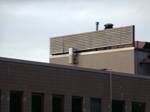
SC01 (cells 1 and 12) are located inside the 'penthouse' atop 276 Turnpike Rd ([https://goo.gl/maps/JcrfVCJBSpy4vNmJ7 Street View]). The antennas were [https://westborough.patriotpermitpro.com/index.php?act=process&id=3308 installed in 2015] and remain the same today, with permits filed [https://westborough.patriotpermitpro.com/index.php?act=process&id=13384 to add PCS] in 2019 (but I'm not sure if they ever went through). | SC01 (cells 1 and 12) are located inside the 'penthouse' atop 276 Turnpike Rd ([https://goo.gl/maps/JcrfVCJBSpy4vNmJ7 Street View]). The antennas were [https://westborough.patriotpermitpro.com/index.php?act=process&id=3308 installed in 2015] and remain the same today, with permits filed [https://westborough.patriotpermitpro.com/index.php?act=process&id=13384 to add PCS] in 2019 (but I'm not sure if they ever went through). | ||
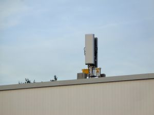
SC02 (cell 22) is located at 150 Turnpike Rd, atop McGovern's service garage ([https://goo.gl/maps/n38h1RDWYBX2mwVd8 Street View]). This was [https://westborough.patriotpermitpro.com/index.php?act=process&id=4283 installed in 2015] and hasn't been modified since - [https://westborough.patriotpermitpro.com/index.php?act=process&id=4753 an electrical permit] from the initial install notes that it is a "single antenna cellsite." | [[File:DSC00789-darktable-out.jpg|300px]] | ||
SC02 (cell 22) is located at 150 Turnpike Rd, atop McGovern's service garage ([https://goo.gl/maps/n38h1RDWYBX2mwVd8 Street View]). This was [https://westborough.patriotpermitpro.com/index.php?act=process&id=4283 installed in 2015] and hasn't been modified since - [https://westborough.patriotpermitpro.com/index.php?act=process&id=4753 an electrical permit] from the initial install notes that it is a "single antenna cellsite." | |||
[[File:DSC00782-darktable-out.jpg|300px]] | |||
[[File:DSC00786-out.jpg|300px]] | |||
Revision as of 00:54, 27 May 2022
This eNB is used for two cell sites. Verizon treats them as a small cell group (specifically, WESTBORO_OTIS_ST_MA_SC01 and SC02), but they are both rooftop installations. It is labeled "Verizon C-RAN" in some documents.
SC01 (cells 1 and 12) are located inside the 'penthouse' atop 276 Turnpike Rd (Street View). The antennas were installed in 2015 and remain the same today, with permits filed to add PCS in 2019 (but I'm not sure if they ever went through).
SC02 (cell 22) is located at 150 Turnpike Rd, atop McGovern's service garage (Street View). This was installed in 2015 and hasn't been modified since - an electrical permit from the initial install notes that it is a "single antenna cellsite."


