310 260 405808: Difference between revisions
add photo |
add speed test, Google Street view, and other info |
||
| Line 1: | Line 1: | ||
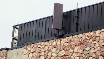
This is a T-Mobile cell site with limited bands mounted on UCCS University Hall. It is missing B41/N41. | This is a T-Mobile cell site with limited bands mounted on UCCS University Hall. It is missing B41/N41. | ||
LTE eNB 405808 was first seen December 2022, while eNB 22461 was seen between | LTE eNB 405808 was first seen December 2022, while decommissioned eNB 22461 was seen between October 2015 and November 2022. | ||
eNB 405808 | == Photo == | ||
[[File:20230324_162437 T-Mobile eNB 405808.jpg|400px|painted antenna on east side of building, taken 3/24/2023]] | |||
As of June 2021, there were older antennas ([https://www.google.com/maps/@38.8892247,-104.7869439,3a,15y,270.88h,102.95t/data=!3m10!1e1!3m8!1s-tWE4S1CqlCIpw_LDIUzsQ!2e0!6shttps:%2F%2Fstreetviewpixels-pa.googleapis.com%2Fv1%2Fthumbnail%3Fpanoid%3D-tWE4S1CqlCIpw_LDIUzsQ%26cb_client%3Dmaps_sv.tactile.gps%26w%3D203%26h%3D100%26yaw%3D67.68046%26pitch%3D0%26thumbfov%3D100!7i16384!8i8192!9m2!1b1!2i24 Google Street View]). | |||
As of May 2011, there were no antennas ([https://www.google.com/maps/@38.8893277,-104.7873138,3a,75y,251.91h,105.85t/data=!3m7!1e1!3m5!1s9bDPGswEIaHa-Wq-Gi1sig!2e0!6shttps:%2F%2Fstreetviewpixels-pa.googleapis.com%2Fv1%2Fthumbnail%3Fpanoid%3D9bDPGswEIaHa-Wq-Gi1sig%26cb_client%3Dmaps_sv.tactile.gps%26w%3D203%26h%3D100%26yaw%3D324.89963%26pitch%3D0%26thumbfov%3D100!7i13312!8i6656 Google Street View]). | |||
== Speed test == | |||
Galaxy S22, Google Fi, close range, March 2023, NR NSA (B2+N41+N41+B66): 376.91/6.83 88ms ([https://www.speedtest.net/result/a/9156617599 results], [[:File:20230324_162532-Service mode-TMobile eNB 405808.jpg|service mode]]). The N41 is coming from another physical site. | |||
== Location == | |||
eNB 405808 signal was -53 dBm at 38.88943488,-104.78756164 (next to UCCS University Hall, on the north west side of Union and Austin Bluffs). | |||
[https://www.google.com/maps/@38.8894188,-104.7846317,3a,15y,341.16h,92.45t/data=!3m10!1e1!3m8!1sscdvG_EzNiFy5BMIur3kmw!2e0!6shttps:%2F%2Fstreetviewpixels-pa.googleapis.com%2Fv1%2Fthumbnail%3Fpanoid%3DscdvG_EzNiFy5BMIur3kmw%26cb_client%3Dmaps_sv.tactile.gps%26w%3D203%26h%3D100%26yaw%3D295.2453%26pitch%3D0%26thumbfov%3D100!7i16384!8i8192!9m2!1b1!2i24 Google Street View photo] | There is [https://www.pprbd.org/Plan/Details?Id=C173076&SpliceNum=&tid=163793 plan C173076] for 2297 FLINTRIDGE DR, which is a monopole 1000 ft to the east from University Hall. The Flintridge address has antenna permits from 1998, and it may be a legacy site. For Flintridge, see the | ||
[https://www.google.com/maps/@38.8894188,-104.7846317,3a,15y,341.16h,92.45t/data=!3m10!1e1!3m8!1sscdvG_EzNiFy5BMIur3kmw!2e0!6shttps:%2F%2Fstreetviewpixels-pa.googleapis.com%2Fv1%2Fthumbnail%3Fpanoid%3DscdvG_EzNiFy5BMIur3kmw%26cb_client%3Dmaps_sv.tactile.gps%26w%3D203%26h%3D100%26yaw%3D295.2453%26pitch%3D0%26thumbfov%3D100!7i16384!8i8192!9m2!1b1!2i24 Google Street View photo]. | |||
[[Category:T-Mobile in El Paso County Colorado]] | [[Category:T-Mobile in El Paso County Colorado]] | ||
Revision as of 14:32, 25 March 2023
This is a T-Mobile cell site with limited bands mounted on UCCS University Hall. It is missing B41/N41.
LTE eNB 405808 was first seen December 2022, while decommissioned eNB 22461 was seen between October 2015 and November 2022.
Photo
As of June 2021, there were older antennas (Google Street View).
As of May 2011, there were no antennas (Google Street View).
Speed test
Galaxy S22, Google Fi, close range, March 2023, NR NSA (B2+N41+N41+B66): 376.91/6.83 88ms (results, service mode). The N41 is coming from another physical site.
Location
eNB 405808 signal was -53 dBm at 38.88943488,-104.78756164 (next to UCCS University Hall, on the north west side of Union and Austin Bluffs).
There is plan C173076 for 2297 FLINTRIDGE DR, which is a monopole 1000 ft to the east from University Hall. The Flintridge address has antenna permits from 1998, and it may be a legacy site. For Flintridge, see the Google Street View photo.
